The flood watch for Coral Springs ended at 7 a.m. Friday after up to 10.69 inches of rain in three days. Broward schools stay closed until Nov. 30.
Updated Nov. 20: the flood watch ended at 7 a.m. Friday. Broward County Public Schools stayed closed Friday, and students now return Monday, Nov. 30, after Thanksgiving break.
Updated Nov. 19: the National Weather Service extended the flood watch to 7 a.m. Friday and published three-day rain totals. Broward County Public Schools stayed closed Thursday.
The flood watch for Coral Springs ended at 7 a.m. Friday after three days of heavy rain. The gauge at the Coral Springs Public Safety Building recorded 10.69 inches in 72 hours.
The National Weather Service in Miami let the watch expire at 7 a.m. “The flash flooding threat has ended,” it said at 6:40 a.m. The watch covered Broward, Palm Beach and Miami-Dade counties, including the Metro Broward zone that takes in Coral Springs.
Three days of rain
The weather service published its preliminary 72-hour rain totals at 5:06 p.m. Thursday. The figures run to about 5 p.m. Thursday. The weather service had published no later totals by Friday evening.
| Gauge, as the weather service names it | Rain in 72 hours |
|---|---|
| 2 W Parkland | 12.06 inches |
| 1 SE Coral Springs (Public Safety Building) | 10.69 inches |
| 1 SE North Lauderdale | 10.62 inches |
| 2 SE Coral Springs | 10.53 inches |
| 2 SE Parkland | 9.71 inches |
| 2 N Tamarac | 9.66 inches |
| 1 NW Coral Springs | 8.91 inches |
| 1 W Parkland | 8.43 inches |
| 6 NW Coral Springs | 7.03 inches |
| 2 W Coral Springs | 6.63 inches |
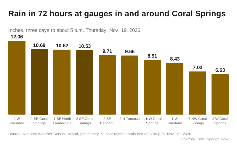
The highest total in Broward County was 17.59 inches, about two miles southeast of Plantation. Plantation is about 11 miles south of Coral Springs.
Schools closed until Nov. 30
Broward County Public Schools closed all schools and district offices Wednesday because of flooding across the county. It kept them closed again Thursday.
On Thursday evening the district said schools and offices would stay closed Friday too. “With additional rainfall forecast and ongoing flooding across Broward County, conditions remain unsafe for students and staff to travel to and from school,” it said in a post on its official Instagram account.
That makes three school days lost before the scheduled Thanksgiving break. The district’s plan:
- district offices are expected to reopen Monday, Nov. 23
- schools stay closed Nov. 23-27 for Thanksgiving break
- students are due back Monday, Nov. 30, “if conditions allow,” after teams check campuses
“Due to instructional time missed, the school calendar will be adjusted,” the district said. It will share details with families after the break.
Flood advisories Thursday
The weather service named Coral Springs in two flood advisories Thursday morning:
- the 8:44 a.m. advisory said 1 to 2 inches had fallen across northern Broward County
- the 9:58 a.m. update kept it in force until 11:15 a.m.
Both warned of “minor flooding in low-lying and poor drainage areas.” The weather service let the advisory expire at 11:15 a.m., when the heavy rain had ended. It asked people to “continue to heed remaining road closures.”
The weekend forecast
The weather service’s forecast for Coral Springs, updated at 3:47 p.m. Friday, has one more wet afternoon before a drier Sunday and Monday:
| Period | Chance of rain | Forecast |
|---|---|---|
| Friday night | Not given | Partly cloudy, low around 69 |
| Saturday | 60% | Storms likely 2 to 3 p.m., a tenth to a quarter of an inch, high near 83 |
| Saturday night | 20% | Slight chance of storms before 11 p.m., low around 70 |
| Sunday | 40% | Showers possible after 1 p.m., high near 85 |
| Monday | Not given | Partly sunny, high near 81 |
What the watch said Thursday
Before it ended, the extended watch said 3 to 5 inches had fallen widely along the east coast of South Florida over several days, with pockets of 8 to 15 inches. Those areas were “most susceptible” to more rain, it said.
Wednesday’s report
On Wednesday, a gauge about two miles southeast of the city center recorded 7.47 inches in the 24 hours to 3:35 p.m. The National Weather Service in Miami published those preliminary 24-hour rain reports at 3:53 p.m. Wednesday. The weather service says the reports are preliminary.
How much rain fell Wednesday
Eleven gauges in and around Coral Springs caught between 4.88 and 7.47 inches. The figures run to between 3:15 p.m. and 3:40 p.m. Wednesday.
| Gauge, as the weather service names it | Rain in 24 hours |
|---|---|
| 2 SE Coral Springs | 7.47 inches |
| 2 W Parkland | 7.26 inches |
| 1 SE North Lauderdale | 6.54 inches |
| 2 W Coral Springs | 6.14 inches |
| 1 SE Coral Springs | 6.07 inches |
| 2 NW Tamarac | 5.83 inches |
| 1 W Parkland | 5.58 inches |
| 1 N North Lauderdale | 5.09 inches |
| 1 NW Coral Springs | 5.04 inches |
| 2 SE Parkland | 4.90 inches |
| 6 NW Coral Springs | 4.88 inches |
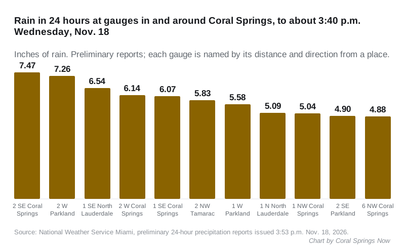
Margate, about three miles east, recorded 6.13 inches in the 24 hours to 7 a.m. Wednesday.
The heaviest rain in Broward County fell farther south. A gauge in Plantation, about 11 miles south, recorded 15.32 inches in the 24 hours to 8 a.m. Wednesday.
The first flood watch
The weather service issued the flood watch at 12:50 p.m. Wednesday. It covered Broward, Palm Beach and Miami-Dade counties, including the Metro Broward zone that takes in Coral Springs.
It said flash flooding “continues to be possible” through Thursday evening. Its forecast:
- several rounds of storms bringing 2 to 4 inches through late Thursday
- 6 to 8 inches in some places, and more than 10 inches in isolated spots
- rain falling at 1 to 2 inches an hour in some storms
The weather service said flooding may happen “in poor drainage and urban areas.” It told people to watch later forecasts and “be prepared to take action should Flash Flood Warnings be issued.”
A watch means flooding is possible. A warning means it is happening or about to.
Wind on Wednesday
A separate wind advisory ran until 1 a.m. Thursday for Metro Broward. It forecast east winds of 25 to 30 mph with frequent gusts up to 45 mph. The weather service said tree limbs could come down and “a few power outages may result.”
A station about a mile southeast of Coral Springs logged 33 mph at 12:30 p.m. Wednesday, the weather service’s wind reports show.
What the city has posted
The city’s news page had no notice about the rain or flooding as of Friday evening. Its latest post was dated Nov. 13.
What it means for you
- No school for Broward students until Monday, Nov. 30. Watch the district’s news page after Thanksgiving for the changed calendar and any make-up days.
- Ground is still saturated. Saturday’s storms are forecast to bring only a tenth to a quarter of an inch, but low streets and parking lots can still hold water after a downpour.
- Do not drive through standing water or around barricades.
- Stay out of the ocean. The rip current risk for coastal Broward was high through Friday evening.
Have your say